Log in
All resources
Create a design
516 Free Images of 1860 Maps
gemeente atlas van nederland - south holland
1860s maps of south holland
gemeente atlas van nederland - north holland
1860s maps of north holland
media from regionaal archief alkmaar
hoeksche waard in the 19th century
goeree-overflakkee in the 19th century
maps of polders in south holland
spijkenisse in the 19th century
zuidplas in the 19th century
gemeente atlas van nederland - south holland
1860s maps of south holland
gemeente atlas van nederland - south holland
1860s maps of south holland
gemeente atlas van nederland - south holland
maps of heerjansdam
gemeente atlas van nederland - south holland
1860s maps of south holland
gemeente atlas van nederland - south holland
1860s maps of south holland
gemeente atlas van nederland - south holland
old maps of eiland van dordrecht
gemeente atlas van nederland - north holland
1860s maps of north holland
gemeente atlas van nederland - south holland
maps of ameide
gemeente atlas van nederland - south holland
1860s maps of south holland
gemeente atlas van nederland - south holland
1860s maps of south holland
gemeente atlas van nederland - north holland
maps of schermer
gemeente atlas van nederland - south holland
maps of haastrecht
gemeente atlas van nederland - south holland
1860s maps of south holland
gemeente atlas van nederland - south holland
strevelshoek
gemeente atlas van nederland - south holland
1860s maps of south holland
gemeente atlas van nederland - south holland
maps of hendrik-ido-ambacht
gemeente atlas van nederland - south holland
1860s maps of south holland
gemeente atlas van nederland - south holland
1860s maps of south holland
gemeente atlas van nederland - south holland
1860s maps of south holland
hamburger stadtentwässerung
1864 maps of hamburg
media from regionaal archief alkmaar
maps of texel
media from regionaal archief alkmaar
old maps of koedijk
gemeente atlas van nederland - north holland
maps of bergen, north holland
media from regionaal archief alkmaar
maps of wieringen
gemeente atlas van nederland - south holland
1860s maps of south holland
gemeente atlas van nederland - south holland
maps of nieuwenhoorn
gemeente atlas van nederland - north holland
19th-century maps of amsterdam
gemeente atlas van nederland - south holland
1860s maps of south holland
media from regionaal archief alkmaar
maps of heerhugowaard
media from regionaal archief alkmaar
maps of wieringerwaard
books published in saint petersburg
boris andreevich dorn
hakodate city central library
maps by takeshiro matsuura
media from regionaal archief alkmaar
maps of heiloo
gemeente atlas van nederland - north holland
maps of beemster
gemeente atlas van nederland - south holland
maps of krimpen aan de lek
gemeente atlas van nederland - north holland
old maps of amsterdam
gemeente atlas van nederland - south holland
1860s maps of south holland
gemeente atlas van nederland - south holland
1860s maps of south holland
gemeente atlas van nederland - south holland
old maps of brielle
gemeente atlas van nederland - south holland
giessen (river south-holland)
gemeente atlas van nederland - south holland
maps of lisse
gemeente atlas van nederland - south holland
1860s maps of south holland
cornell's primary geography (1860)
1867 maps of africa
gemeente atlas van nederland - south holland
maps of waddinxveen
gemeente atlas van nederland - south holland
giessen (river south-holland)
maps of nieuw-helvoet
nieuw-helvoet
gemeente atlas van nederland - groningen
maps of appingedam
gemeente atlas van nederland - north holland
old maps of alkmaar
gemeente atlas van nederland - south holland
1860s maps of south holland
media from regionaal archief alkmaar
old maps of schagen
gemeente atlas van nederland - south holland
maps of zoeterwoude
maps by takeshiro matsuura
old maps of ezo
gemeente atlas van nederland - south holland
19th-century maps of rotterdam
gemeente atlas van nederland - south holland
19th-century maps of rotterdam
gemeente atlas van nederland - south holland
old maps of gouda
gemeente atlas van nederland - south holland
1860s maps of south holland
gemeente atlas van nederland - south holland
1860s maps of south holland
gemeente atlas van nederland - south holland
1860s maps of south holland
gemeente atlas van nederland - south holland
1860s maps of south holland
gemeente atlas van nederland - south holland
1860s maps of south holland
gemeente atlas van nederland - south holland
old maps of gouda
cornell's primary geography (1860)
1867 maps of asia
gemeente atlas van nederland - south holland
old maps of leiden
gemeente atlas van nederland - south holland
1860s maps of south holland
gemeente atlas van nederland - south holland
1860s maps of south holland
gemeente atlas van nederland - south holland
maps of piershil
gemeente atlas van nederland - south holland
maps of goudswaard
gemeente atlas van nederland - south holland
1860s maps of south holland
maps in the rijksmuseum amsterdam
published by frans buffa & zonen
gemeente atlas van nederland - south holland
maps of wassenaar
gemeente atlas van nederland - south holland
1860s maps of south holland
gemeente atlas van nederland - south holland
1860s maps of south holland
gemeente atlas van nederland - north holland
maps of texel
gemeente atlas van nederland - south holland
1860s maps of south holland
gemeente atlas van nederland - north holland
old maps of haarlem
gemeente atlas van nederland - north holland
maps of bloemendaal
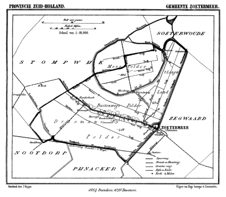
gemeente atlas van nederland - south holland
maps of zoetermeer
gemeente atlas van nederland - south holland
1860s maps of south holland
media from regionaal archief alkmaar
oudkarspel
gemeente atlas van nederland - north holland
maps of muiden
gemeente atlas van nederland - south holland
1860s maps of south holland
gemeente atlas van nederland - south holland
1860s maps of south holland
gemeente atlas van nederland - south holland
maps of kedichem
gemeente atlas van nederland - north holland
maps of uithoorn
gemeente atlas van nederland - north holland
maps of zandvoort
gemeente atlas van nederland - north holland
blokker
gemeente atlas van nederland - south holland
maps of zuid-beijerland
media from regionaal archief alkmaar
maps of barsingerhorn
gemeente atlas van nederland - south holland
1860s maps of south holland
gemeente atlas van nederland - south holland
old maps of delft
gemeente atlas van nederland - north holland
old maps of haarlem
gemeente atlas van nederland - south holland
maps of spijkenisse
historical
history
historical
history
chicago and the midwest, newberry library
globes by rand mcnally
1860s maps of china
1863 maps of asia
gemeente atlas van nederland - south holland
1860s maps of south holland
gemeente atlas van nederland - south holland
1860s maps of south holland
gemeente atlas van nederland - north holland
old maps of alkmaar
gemeente atlas van nederland - south holland
1860s maps of south holland
201 - 300 of 516
Next page
/ 6